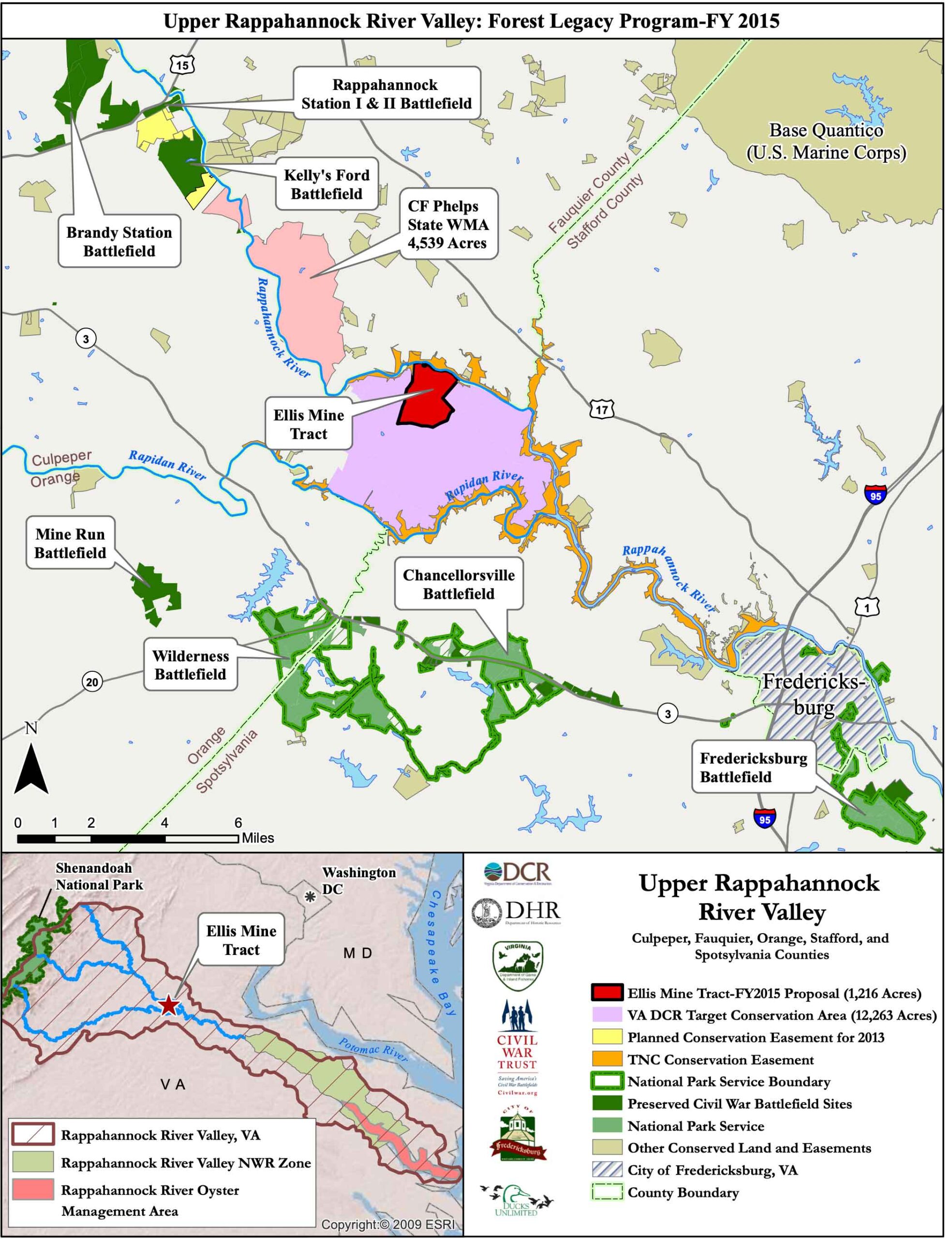


The “5 County Panhandle” (5CP) project protects 1216 acres at the confluence of the Rappahannock and Rapidan Rivers in Culpeper County, VA. This property represents one of the largest private landholdings in the 5 county panhandle and has been professionally managed as a working forest by the owners for over 60 years. In addition to the Forest management plan currently in place, the property will be managed to protect the watershed (HUC 02080103 & 04) and water quality which will favorably impact local area streams, the Rappahannock River Valley National Wildlife Refuge, and the greater Chesapeake Bay management objectives. This property provides connectivity between the Shenandoah National Park, Rappahannock Valley NWR, existing easements jointly held by two state agencies and one NGO, and the Chesapeake Bay Oyster Management zone. Additionally, connectivity between CF Phelps State Wildlife Management area, Brandy Station BF, Kelly’s Ford BF, Rappahannock Station I&II BF, Wilderness Battlefield National Park, Chancellorsville Battlefield National Park, and Quantico Marine Base is substantially enhanced in the RRV. This is a key parcel per Virginia Department of Conservation and Recreation focus area in the 5 county panhandle.
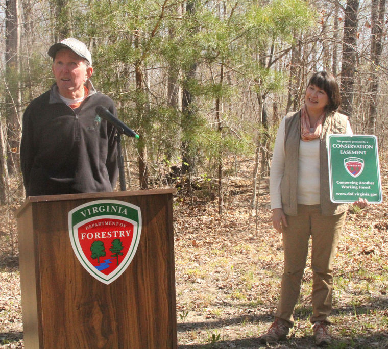
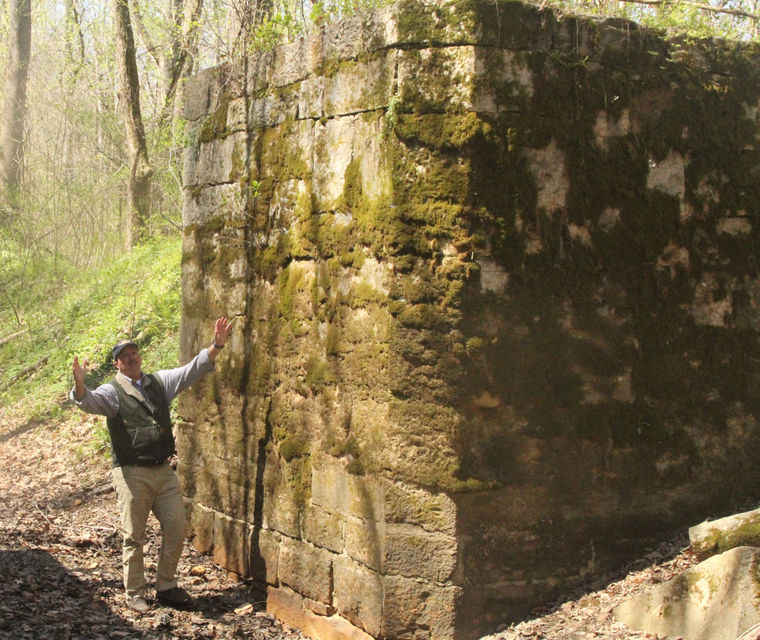
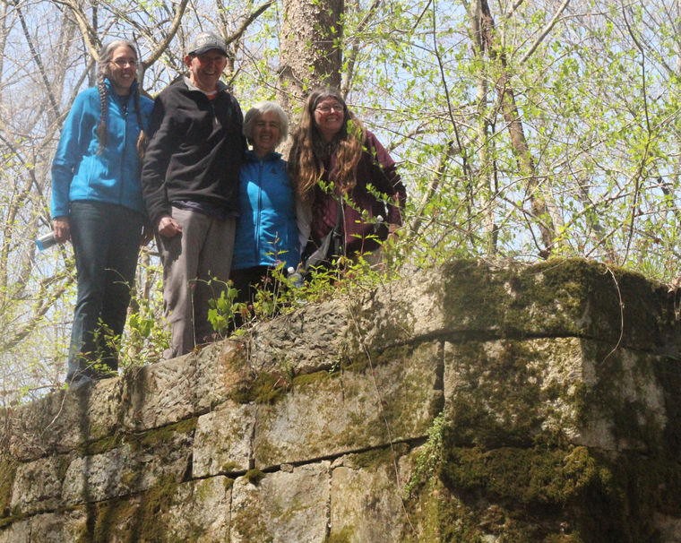
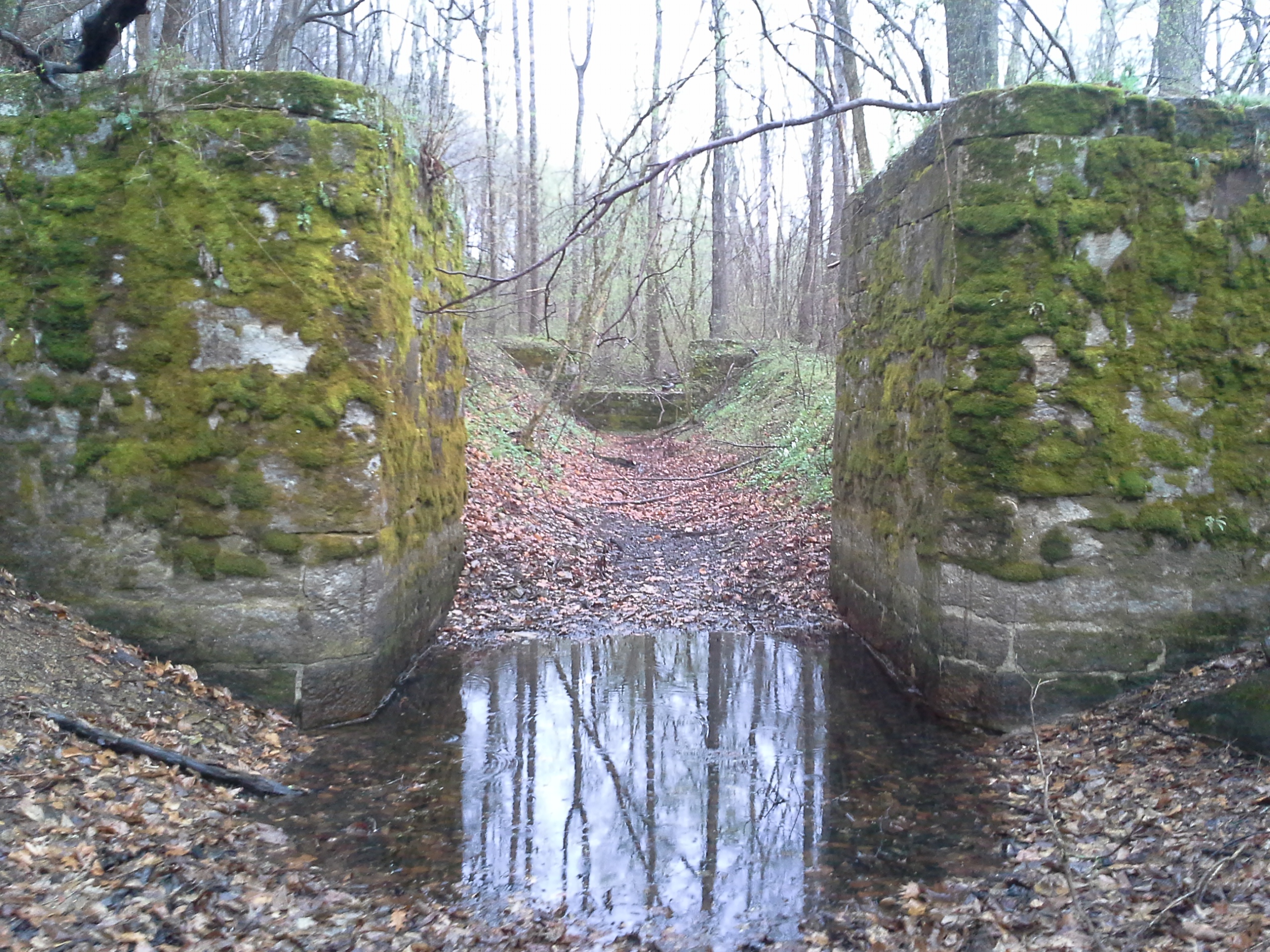
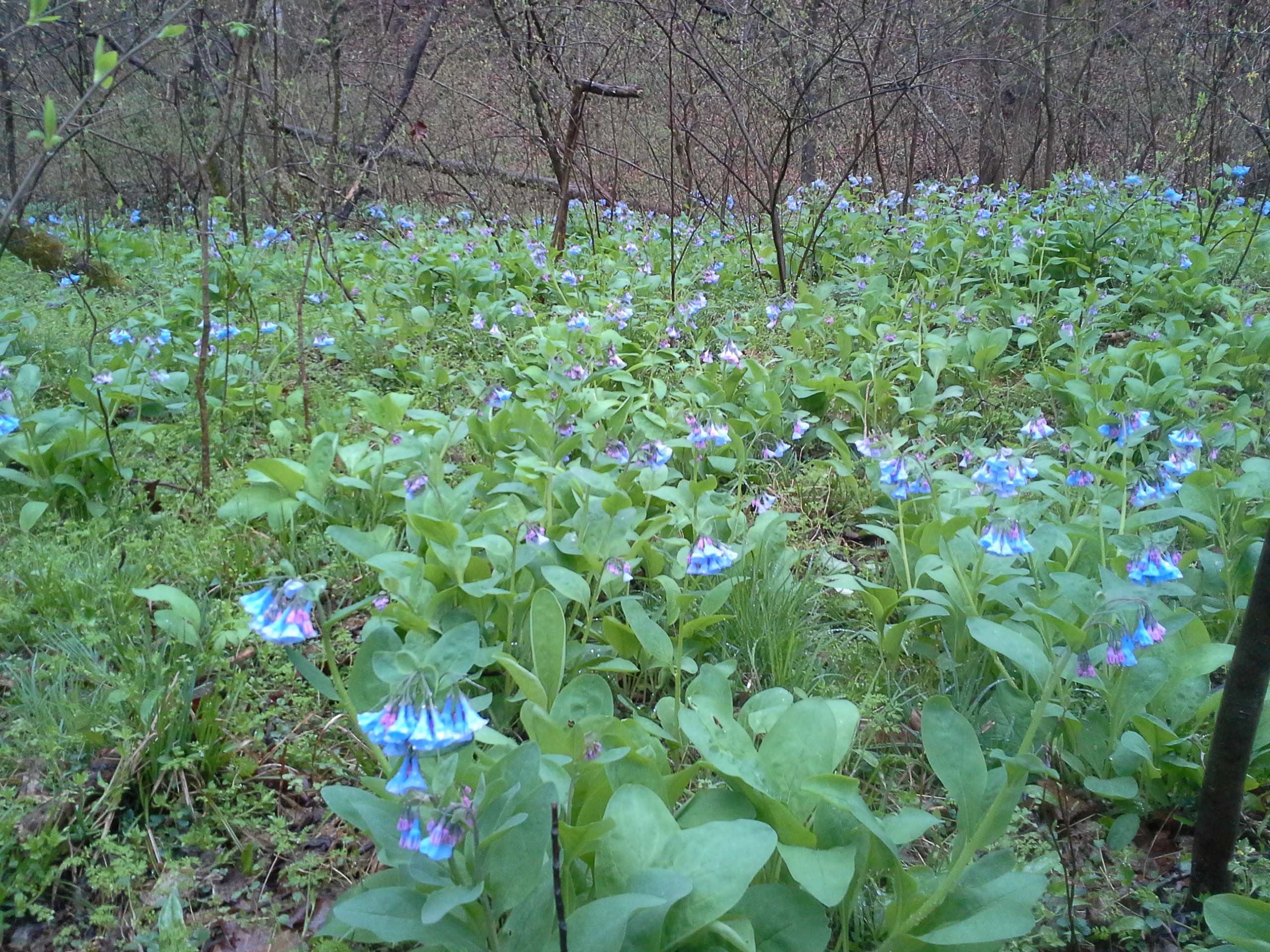
BY TEE CLARKSON SPECIAL CORRESPONDENT | POSTED: SATURDAY, APRIL 16, 2016 10:30 PM In the past several decades, expansion out of Fredericksburg has mostly headed north and west, largely following Route 3 toward Culpeper and Route 17 toward Warrenton. Shopping centers, big-box stores and subdivisions have gobbled up what was once pristine farmland and rolling expanses of wilderness. Just a handful of miles out of Fredericksburg on Route 3, signs acknowledge the site of one of the most famous battles of the Civil War, the Battle of Chancellorsville. For nearly a week, the Union and Confederate armies waged bloody war in these fields. Now, bulldozers and front-end loaders work dozens of acres on top of a hill where the men fought, clearing 2-acre lots for The Estates of Chancellorsville. It’s hard not to harken back 153 years to the days of the battle and think how much different the world was, how different the landscape appeared. It’s equally difficult not to imagine the future and what this land may look like 150 years from now. Last Wednesday marked an important day for this area, one whose accomplishments will be carried forward as long as the Battle of Chancellorsville and as long as man inhabits these grounds, as the Department of Forestry celebrated the closing of a conservation easement on 1,219 acres along the Rappahannock River known as the Ellis Mine tract. The property, owned by the Purcell family of Louisa County, was one of the most prolific areas in Virginia for mining gold in the mid-1800s. Dickie Purcell remembers visiting the property as a boy, shortly after his father acquired it in the early 1950s. “I used to come over here with my dad,” Purcell said. “I thought it was the most isolated place to get to. It’s a special piece of land just 15 minutes from Fredericksburg and an hour from Northern Virginia.” The Purcells were able to place the property in a conservation easement through a grant from the U.S. Forest Service’s Forest Legacy Program. It was an extremely time-consuming and competitive process, and the family had been working on the grant for three years with the help of the Virginia Department of Forestry and Jamie Craig of Beechtree Group out of Falls Church. “The Ellis Mine tract received a presidential grant from President Obama, of which only 15 were awarded in 2015, making it an honor very few conservationists may claim and the single most competitive grant in the country,” Craig said. Until the easement was finalized, the Purcell’s property represented a significant piece of unprotected land along the Rappahannock River just west of Fredericksburg where more than 16,000 acres has been protected by the Nature Conservancy, the Virginia Department of Game and Inland Fisheries, the Civil War Trust and private landowners. “The Ellis Mine tract represents the largest unprotected stretch of river frontage inside the Nature Conservancy easement. Its protection will forever provide forested views along this pristine section of the Rappahannock River,” Craig said. Nearly all of the 1,219 acres are forested, most in older stands of hardwoods. As part of the easement restrictions, the Purcell family surrendered the timber rights to 200 acres of “old growth” forest along the Rappahannock River, as well as 14 development rights. On Wednesday, those in attendance, including State Forester Bettina Ring, followed an old road down a steep incline toward the river before veering off on a game trail, crossing a small creek and emerging in the lowgrounds along the river covered in blooming bluebells. “Healthy watersheds protect us all,” Ring said. “Forests play such a critical role in their protection. This is a gem of a project that shows all of these resources can be protected.” The only sign of man is the remnant of lock 16 from the canal that used to follow the river, a standing monument to a different time. Just upstream from the lock, the river braids around an island and tumbles over a ledge before continuing on to provide drinking water for the City of Fredericksburg before ultimately spilling into the Chesapeake Bay. The group largely was quiet, the way people tend to get around moving water and wilderness. “It’s as quiet and as peaceful as can be,” Dickie Purcell said. And, thankfully, it appears that it will remain that way.
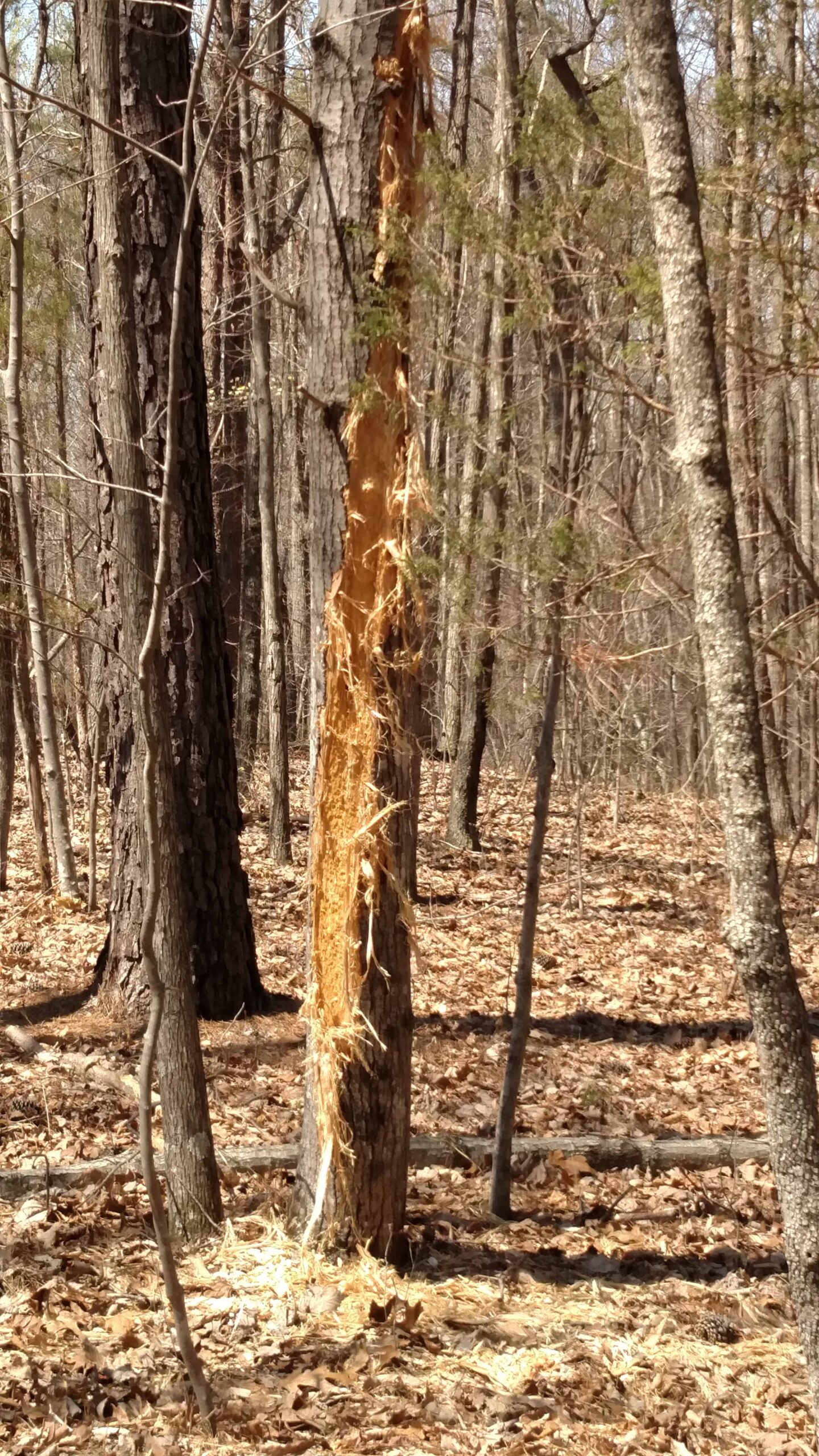
Learn MorePosted: Thursday, April 14, 2016 5:40 pm RICHARDSVILLE – An adventurous group of conservationists walked deep into the woods in southeastern Culpeper County Wednesday to view the bountiful historic and natural resources spanning the 1,219 acres recently placed in permanent conservation easement, including 1.5 miles of riverfront land in an area once mined for gold. “This will be protected forever,” said State Forrester Bettina Ring in a presentation prior to the hike enjoyed by about a dozen state officials as well as the landowners on a sunny spring morning. “This conservation easement will protect the scenic Rappahannock River, the Chesapeake Bay and the primary source of drinking water for the city of Fredericksburg. This is what we call a win-win-win-win.” The Virginia Department of Forestry, following several years of negotiations, closed this year on the “working forest” conservation easement on land owned by the Purcell family of Louisa County since the 1950s. In addition to its numerous abandoned open-pit gold mine sites from the 1830s, the property is a mixture of mature hardwoods and pines, and home to abundant wildlife including bears, bobcats, coyotes, deer and turkey. RAPPAHANNOCK RIVER CONSERVATION EASEMENT The Virginia Department of Forestry on Wednesday morning announced a major conservation easement of more than 1,200-acres along the Rappahannock River. The state purchased the easement on the rurally located land for $1.085 million with the family donating the remaining value of the property appraised at $1.7 million, according to Larry Mikkelson, acquisition and easement coordinator with the state forestry department. The U.S. Forest Service Forest Legacy Program provided funding for the easement that allows the Purcells to continue to log the land when the trees are mature or dying, followed by reforestation. “We’re not conserving these trees. We’re conserving the land to grow trees over time,” Mikkelson said. As part of the easement, the Purcell family continues to own the property, but with limitations including: 1) it can be divided into no more than seven parcels; 2) no more than two homes, not larger than 4,000-square-feet, can be built on each permitted parcel and 3) a 200-feet buffer of uncut trees must be maintained along the river and 100-feet on both sides of perennial streams. The easement value is generated by the owners giving up 14 potential divisions of the property and the foregone value of the timber on the river and stream buffers where harvest is now prohibited by the easement, according to Mikkelson. In addition to the river frontage, the property has more than six miles of streams, he said. “When the Purcell family purchased this property, they could have easily decided to cut every tree on the property instead of replanting to have a future forest,” said Ring. “Instead of building homes, they looked at what was possible for this land. Because of their generosity, we’re now able to protect the trees that are here, the wildlife, the air and water quality and the beauty and serenity contributes to our wellness and quality of life.” Landowner Dickie Purcell, of the Dick Purcell Land, Cattle & Timber Corporation in Louisa, said the city of Fredericksburg owns most of the land adjoining his property and that much of it was already in conservation easement. “This was a pretty big gap that wasn’t,” he said. “I just feel like this is a special piece of property and I know it has a special meaning for my family.” Purcell’s wife, Brenda, and daughters, Penny and Tammy, attended Wednesday’s event and all participated in the rugged hike to another unique feature — the circa 1840s, hand-laid, stone lock that was once part of the short-lived Rappahannock Canal Company. Jamie Craig, easement consultant with Falls Church-based Beechtree Group, insisted confidently that he could reach the remotely located lock and welcomed anyone to drive along in his four-wheel drive vehicle. “You’ll never see anything like it again,” he promised. Brenda Purcell and her daughters squeezed into the back of his vehicle that also carried a reporter, Dickie Purcell and the state forester. Deeper and deeper into the woods Craig drove on, undeterred by the rugged logging roads made of dirt, dodging deep mud pits and swerving precariously around gashes in the unfinished surface. Following much jostling and a few dicey moments, he finally arrived at a spot where the hikers got out to walk further into the forest, crossing a stream and meandering past bluebells until coming upon the massive, abandoned stone structure that existed at a time when the rivers were the highways, before the advent of the railroad and automobiles. The Purcells and the forestry staff all climbed atop the moss-covered lock to pose for pictures before wandering a short distance away to view the Rappahannock, rapids babbling upstream in proximity to Stafford County and the river’s confluence with the Rapidan. Civil War soldiers crossed the Rappahannock in the area at Ely’s Ford, noted Tammy Purcell, and another group of soldiers came down the Richardsville Road on the way to the Battle of Chancellorsville. Earlier, the area was home to the Manahaoc Indians. “It’s got a lot of great history and as a history lover, it makes it particularly special for me,” said Ms. Purcell. “It’s got so much value for conservation reasons. Penny has a daughter, my other sister has a son and we wanted to be able to leave it to them as it has been for generations.” Multiple voices agreed. “It’s just a beautiful area,” said Virginia Conservation Police Officer Owen Bullard, of Culpeper. “I’m glad to see people are taking steps to protect it.” He saved the day on the way back, appearing with a chainsaw from the back of the caravan, to remove a fallen tree blocking the one-way logging road. Scott Stewart, manager of the Forest Legacy Program, traveled from Washington, D.C. to participate in Wednesday’s gathering. The 1990 Farm Bill authorized the legacy program and since then 2.6 million acres of forest have been conserved nationwide, including nearly 16,000 acres in Virginia, he said. “I am really humbled that I was asked to come down here and share today with you,” Stewart said. “Today we are marking the beginning of the future,” he added, as a woodpecker could be heard tapping in the woods.
Learn More